
Mokhotlong District topographic map
Interactive map
Click on the map to display elevation.
About this map
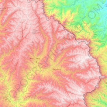
Name: Mokhotlong District topographic map, elevation, terrain.
Location: Mokhotlong District, Lesotho (-29.58166 28.55597 -28.75596 29.45571)
Average elevation: 2,435 m
Minimum elevation: 1,029 m
Maximum elevation: 3,463 m
Other topographic maps
Click on a map to view its topography, its elevation and its terrain.
Ha Long
Lesotho > Thaba-Tseka District
Ha Long, Thaba-Tseka District, Lesotho
Average elevation: 2,412 m
Drakensberg
Drakensberg, Mokhotlong District, Lesotho
Average elevation: 3,286 m