
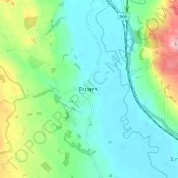
Rathmell topographic map
Interactive map
Click on the map to display elevation.
About this map
Name: Rathmell topographic map, elevation, terrain.
Average elevation: 172 m
Minimum elevation: 121 m
Maximum elevation: 315 m
Other topographic maps
Click on a map to view its topography, its elevation and its terrain.
Kilnsey
United Kingdom > England > North Yorkshire > Craven District
Kilnsey, Craven District, North Yorkshire, England, BD23 5PW, United Kingdom
Average elevation: 286 m
Buckden
United Kingdom > England > North Yorkshire > Craven District
Buckden, Craven District, North Yorkshire, England, United Kingdom
Average elevation: 441 m
Settle
United Kingdom > England > North Yorkshire > Craven District
Settle, Craven District, North Yorkshire, England, United Kingdom
Average elevation: 239 m