
Central Province topographic map
Interactive map
Click on the map to display elevation.
About this map
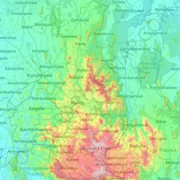
Name: Central Province topographic map, elevation, terrain.
Location: Central Province, Sri Lanka (6.75122 80.42190 8.01235 81.01653)
Average elevation: 389 m
Minimum elevation: 8 m
Maximum elevation: 2,493 m
Other topographic maps
Click on a map to view its topography, its elevation and its terrain.
Castlereigh
Sri Lanka > Central Province > Castlereigh
Castlereigh, Nuwara Eliya District, Central Province, 22050, Sri Lanka
Average elevation: 1,243 m
Nuwara Eliya
Sri Lanka > Central Province > Nuwara Eliya
Nuwara Eliya, Nuwara Eliya District, Central Province, 22000, Sri Lanka
Average elevation: 1,426 m
Kandy
Sri Lanka > Central Province > Kandy
Kandy, Kandy District, Central Province, 20000, Sri Lanka
Average elevation: 621 m
Nattarampota
Sri Lanka > Central Province > Nattarampota
Nattarampota, Kandy District, Central Province, 60622, Sri Lanka
Average elevation: 498 m