
Brussels topographic map
Interactive map
Click on the map to display elevation.
About this map
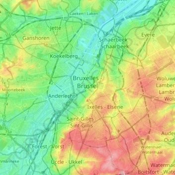
Name: Brussels topographic map, elevation, terrain.
Location: Brussels, Brussels-Capital, Belgium (50.79641 4.33558 50.89050 4.40201)
Average elevation: 54 m
Minimum elevation: 10 m
Maximum elevation: 121 m
Brussels lies in the north-central part of Belgium, about 110 kilometres (68 miles) from the Belgian coast and about 180 km (110 mi) from Belgium's southern tip. It is located in the heartland of the Brabantian Plateau, about 45 km (28 mi) south of Antwerp (Flanders), and 50 km (31 mi) north of Charleroi (Wallonia). Its average elevation is 57 metres (187 feet) above sea level, varying from a low point in the valley of the almost completely covered Senne, which cuts the region from east to west, up to high points in the Sonian Forest, on its southeastern side. In addition to the Senne, tributary streams such as the Maalbeek and the Woluwe, to the east of the region, account for significant elevation differences. Brussels' central boulevards are 15 metres (49 feet) above sea level. The highest point lies at a height of about 108 metres (354 feet), near the Place de l'Altitude Cent/Hoogte Honderdplein, in Forest.