
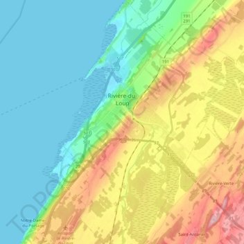
Rivière-du-Loup topographic map
Interactive map
Click on the map to display elevation.
About this map
Name: Rivière-du-Loup topographic map, elevation, terrain.
Average elevation: 64 m
Minimum elevation: -2 m
Maximum elevation: 197 m
La ville est érigée sur une série de plateaux qui s'élèvent à partir du fleuve Saint-Laurent jusqu'à une altitude de près de 200 mètres. Cette topographie accidentée en escalier explique la présence de plusieurs chutes spectaculaires sur la rivière du Loup, au centre de la ville. Ces chutes ont été exploitées dès le XIX siècle pour la production d'énergie, qui à son tour a permis l'installation de nombreuses petites industries. Aujourd'hui encore, la ville demeure un des principaux centres industriels de la région du Bas-Saint-Laurent.
Other topographic maps
Click on a map to view its topography, its elevation and its terrain.
Saint-Hubert-de-Rivière-du-Loup
Canada > Québec > Rivière-du-Loup (MRC)
Saint-Hubert-de-Rivière-du-Loup, Rivière-du-Loup (MRC), Bas-Saint-Laurent, Québec, G0L 3L0, Canada
Average elevation: 341 m
Saint-Antonin
Canada > Québec > Rivière-du-Loup (MRC) > Saint-Antonin
Saint-Antonin, Rivière-du-Loup (MRC), Bas-Saint-Laurent, Québec, G0L 2J0, Canada
Average elevation: 224 m
Notre-Dame du-Portage
Canada > Québec > Rivière-du-Loup (MRC)
Notre-Dame du-Portage, Rivière-du-Loup (MRC), Bas-Saint-Laurent, Québec, Canada
Average elevation: 59 m
Saint-Modeste
Canada > Québec > Rivière-du-Loup (MRC) > Saint-Modeste
Saint-Modeste, Rivière-du-Loup (MRC), Bas-Saint-Laurent, Québec, Canada
Average elevation: 173 m
Saint-Paul-de-la-Croix
Canada > Québec > Rivière-du-Loup (MRC)
Saint-Paul-de-la-Croix, Rivière-du-Loup (MRC), Bas-Saint-Laurent, Québec, G0L 1L0, Canada
Average elevation: 213 m
Fleuve Saint-Laurent, Estuaire moyen
Canada > Québec > Rivière-du-Loup (MRC)
Fleuve Saint-Laurent, Estuaire moyen, Rivière-du-Loup (MRC), Bas-Saint-Laurent, Québec, Canada
Average elevation: 317 m
L'Isle-Verte
Canada > Québec > Rivière-du-Loup (MRC)
L'Isle-Verte, Rivière-du-Loup (MRC), Bas-Saint-Laurent, Québec, G0L 1K0, Canada
Average elevation: 53 m
Saint-Arsène
Canada > Québec > Rivière-du-Loup (MRC)
Saint-Arsène, Rivière-du-Loup (MRC), Bas-Saint-Laurent, Québec, G5R 1L7, Canada
Average elevation: 70 m
Cacouna
Canada > Québec > Rivière-du-Loup (MRC)
Cacouna, Rivière-du-Loup (MRC), Bas-Saint-Laurent, Québec, G0L 1G0, Canada
Average elevation: 27 m