
Kowloon topographic map
Interactive map
Click on the map to display elevation.
About this map
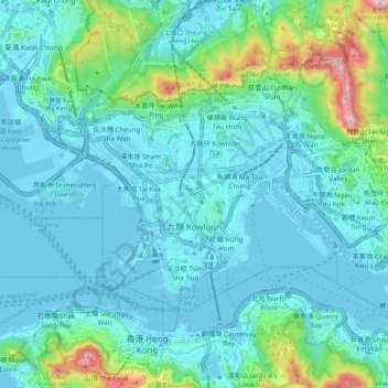
Name: Kowloon topographic map, elevation, terrain.
Location: Kowloon, Hong Kong, 000000, China (22.28228 114.13033 22.35841 114.24558)
Average elevation: 93 m
Minimum elevation: -12 m
Maximum elevation: 590 m
Other topographic maps
Click on a map to view its topography, its elevation and its terrain.
Tai Po
China > Hong Kong > Tai Po District
Tai Po, Tai Po District, New Territories, Hong Kong, China
Average elevation: 155 m
Islands District
Islands District, New Territories, Hong Kong, China
Average elevation: 36 m
Junk Bay
China > Hong Kong > Sai Kung District > Tseung Kwan O
Junk Bay, Kwun Tong District, Tseung Kwan O, Sai Kung District, New Territories, Hong Kong, China
Average elevation: 29 m
Kowloon City District
Kowloon City District, Kowloon, Hong Kong, 000000, China
Average elevation: 37 m