
Castro topographic map
Interactive map
Click on the map to display elevation.
About this map
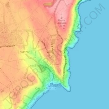
Name: Castro topographic map, elevation, terrain.
Location: Castro, Lecce, Apulia, Italy (39.99396 18.39905 40.02565 18.43592)
Average elevation: 51 m
Minimum elevation: 0 m
Maximum elevation: 123 m
Other topographic maps
Click on a map to view its topography, its elevation and its terrain.
Carpignano Salentino
Carpignano Salentino, Lecce, Apulia, Italy
Average elevation: 58 m
Monteroni di Lecce
Monteroni di Lecce, Lecce, Apulia, 73047, Italy
Average elevation: 39 m
Madonna di Roca Vecchia
Madonna di Roca Vecchia, Roca, Melendugno, Lecce, Apulia, Italy
Average elevation: 6 m