
West Oxfordshire topographic map
Interactive map
Click on the map to display elevation.
About this map
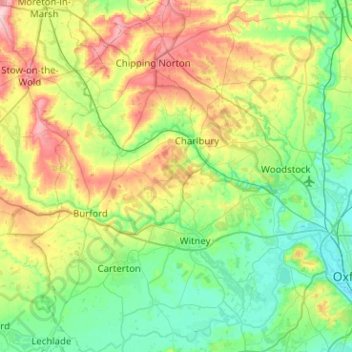
Name: West Oxfordshire topographic map, elevation, terrain.
Average elevation: 119 m
Minimum elevation: 55 m
Maximum elevation: 273 m
Other topographic maps
Click on a map to view its topography, its elevation and its terrain.
Combe
United Kingdom > England > West Oxfordshire
Combe, West Oxfordshire, Oxfordshire, South East, England, United Kingdom
Average elevation: 106 m
Cornbury and Wychwood
United Kingdom > England > West Oxfordshire
Cornbury and Wychwood, West Oxfordshire, Oxfordshire, South East, England, United Kingdom
Average elevation: 146 m
Elm Bank
United Kingdom > England > West Oxfordshire
Elm Bank, West Oxfordshire, Oxfordshire, South East, England, OX29 0SY, United Kingdom
Average elevation: 101 m
Neat Enstone
United Kingdom > England > West Oxfordshire > Neat Enstone
Neat Enstone, West Oxfordshire, Oxfordshire, South East England, England, OX7 4NX, United Kingdom
Average elevation: 159 m