
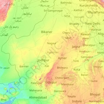
Rajasthan topographic map
Interactive map
Click on the map to display elevation.
About this map
Name: Rajasthan topographic map, elevation, terrain.
Location: Rajasthan, India (23.05866 69.48444 30.19825 78.27201)
Average elevation: 254 m
Minimum elevation: -5 m
Maximum elevation: 2,299 m
The Aravalli Range runs across the state from the southwest peak Guru Shikhar (Mount Abu), which is 1,722 metres (5,650 ft) in height, to Khetri in the northeast. This range divides the state into 60% in the northwest of the range and 40% in the southeast. The northwest tract is sandy and unproductive with little water but improves gradually from desert land in the far west and northwest to comparatively fertile and habitable land towards the east. The area includes the Thar Desert. The south-eastern area, higher in elevation (100 to 350 m above sea level) and more fertile, has a very diversified topography. In the south lies the hilly tract of Mewar. In the southeast, a large area within the districts of Kota and Bundi forms a tableland. To the northeast of these districts is a rugged region (badlands) following the line of the Chambal River. Farther north the country levels out; the flat plains of the northeastern Bharatpur district are part of an alluvial basin. Merta City lies in the geographical center of Rajasthan.
Other topographic maps
Click on a map to view its topography, its elevation and its terrain.
Thanjavur
India > Tamil Nadu > Thanjavur
Thanjavur, Thanjavur District, Tamil Nadu, 613001, India
Average elevation: 49 m
Hyderabad
India > Telangana > Bahadurpura mandal
Hyderabad, Bahadurpura mandal, Hyderabad District, Telangana, India
Average elevation: 549 m
Kanyakumari district
Kanyakumari district, Tamil Nadu, India
Average elevation: 226 m
Bengaluru
India > Karnataka > Bangalore North
Bengaluru, Bangalore North, Bengaluru Urban, Karnataka, India
Average elevation: 886 m
Surat
India > Gujarat > Katargam Taluka > Surat
Surat, Katargam Taluka, Surat, Gujarat, 395001, India
Average elevation: 11 m
Madurai
India > Tamil Nadu > Madurai
Madurai, Madurai South, Madurai district, Tamil Nadu, India
Average elevation: 138 m
Pune
India > Maharashtra > Pune City > Pune
Pune, Pune City, Pune District, Maharashtra, 411001, India
Average elevation: 641 m
Anaikatti
India > Tamil Nadu > Coimbatore North
Anaikatti, Mannarkad, Palakkad District, Kerala, 678741, India
Average elevation: 623 m
Bhatwari
Bhatwari, Uttarkashi District, Uttarakhand, India
Average elevation: 4,570 m
Musi River
Musi River, Hyderabad, Uppal mandal, Medchal–Malkajgiri, Telangana, 5000036, India
Average elevation: 490 m
Mangaluru
India > Karnataka > Mangaluru taluk
Mangaluru, Mangaluru taluk, Dakshina Kannada District, Karnataka, 575001, India
Average elevation: 25 m
Siliguri
India > West Bengal > Siliguri Subdivsion
Siliguri, Siliguri Subdivsion, Darjeeling District, West Bengal, India
Average elevation: 121 m
Vadodara
India > Gujarat > Vadodara Taluka
Vadodara, Vadodara Taluka, Vadodara District, Gujarat, 390001, India
Average elevation: 36 m
Dehradun
India > Uttarakhand > Dehradun
Dehradun, Dehradun District, Uttarakhand, 248001, India
Average elevation: 904 m
Mandi
India > Himachal Pradesh > Mandi
Mandi, Mandi District, Himachal Pradesh, 175001, India
Average elevation: 1,273 m
Sector 62
India > Haryana > Gurugram District
Sector 62, Gurgaon, Gurugram District, Haryana, India
Average elevation: 235 m
Ammanapura Doddi
India > Karnataka > Ramanagara taluk
Ammanapura Doddi, Ramanagara taluk, Ramanagara District, Karnataka, 562138, India
Average elevation: 717 m
Chennai
India > Tamil Nadu > Chennai
Chennai, Chennai District, Tamil Nadu, India
Average elevation: 8 m
Navi Mumbai
India > Maharashtra > Thane > Navi Mumbai
Navi Mumbai, Mumbai Metropolitan Region, Thane, Maharashtra, 400706, India
Average elevation: 30 m
Bhopal
India > Madhya Pradesh > Huzur Tahsil
Bhopal, Huzur Tahsil, Bhopal District, Madhya Pradesh, 462001, India
Average elevation: 498 m
Sirpur
India > Madhya Pradesh > Khalwa Tahsil
Sirpur, Khalwa Tahsil, Khandwa District, Madhya Pradesh, India
Average elevation: 313 m
Joladarashi
India > Andhra Pradesh > Koilkuntla
Joladarashi, Koilkuntla, Nandyal, Andhra Pradesh, 518134, India
Average elevation: 190 m
Karode
India > Tamil Nadu > Vilavancode
Karode, Vilavancode, Kanniyakumari District, Tamil Nadu, 699502, India
Average elevation: 42 m
Karakulam
India > Kerala > Nedumangad
Karakulam, Nedumangad, Thiruvananthapuram District, Kerala, 695564, India
Average elevation: 57 m
Vellarada
India > Kerala > Neyyattinkara
Vellarada, Neyyattinkara, Thiruvananthapuram District, Kerala, 695505, India
Average elevation: 139 m
Mattupetty
Mattupetty, Devikulam, Idukki District, Kerala, 685616, India
Average elevation: 1,694 m
Thorapalli Agraharam
India > Tamil Nadu > Hosur
Thorapalli Agraharam, Hosur, Krishnagiri District, Tamil Nadu, India
Average elevation: 821 m
Tral
Tral, Pulwama District, Jammu and Kashmir, 192123, India
Average elevation: 2,528 m
Ooty Lake
India > Tamil Nadu > Udhagamandalam > Udhagamandalam
Ooty Lake, Udhagamandalam, The Nilgiris District, Tamil Nadu, 643001, India
Average elevation: 2,235 m
Vairavanpatti
India > Tamil Nadu > Thiruppathur
Vairavanpatti, Thiruppathur, Sivagangai District, Tamil Nadu, 630207, India
Average elevation: 103 m