
Constanța topographic map
Interactive map
Click on the map to display elevation.
About this map
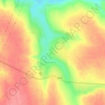
Name: Constanța topographic map, elevation, terrain.
Location: Pietreni, Constanța, 907112, Romania (44.09063 28.06185 44.10550 28.07533)
Average elevation: 121 m
Minimum elevation: 69 m
Maximum elevation: 152 m
Other topographic maps
Click on a map to view its topography, its elevation and its terrain.
Piatra Fântânele
Piatra Fântânele, Bistrița-Năsăud, 427363, Romania
Average elevation: 1,080 m
Retezat National Park
Retezat National Park, Hunedoara, Romania
Average elevation: 1,443 m