
Mont Amba topographic map
Interactive map
Click on the map to display elevation.
About this map
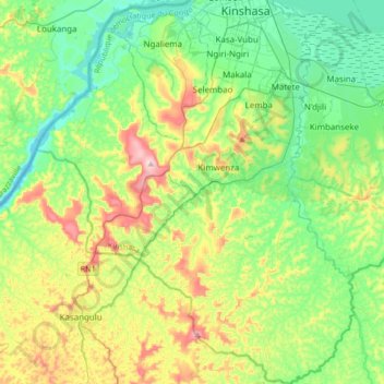
Name: Mont Amba topographic map, elevation, terrain.
Location: Mont Amba, Kinshasa, Democratic Republic of the Congo (-4.64889 15.12944 -4.31290 15.40837)
Average elevation: 359 m
Minimum elevation: 237 m
Maximum elevation: 641 m
Other topographic maps
Click on a map to view its topography, its elevation and its terrain.
Khartoum
Democratic Republic of the Congo > Kinshasa
Khartoum, Ngiri-Ngiri, Kinshasa, Democratic Republic of the Congo
Average elevation: 297 m
Mont Amba
Democratic Republic of the Congo > Kinshasa > Mbanza Lemba
Mont Amba, Mbanza Lemba, Lemba, Kinshasa, Democratic Republic of the Congo
Average elevation: 404 m
Kinshasa
Democratic Republic of the Congo > Kinshasa
Kinshasa, Aketi, Kinshasa, Democratic Republic of the Congo
Average elevation: 316 m