
Kars topographic map
Interactive map
Click on the map to display elevation.
About this map
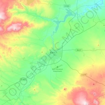
Name: Kars topographic map, elevation, terrain.
Average elevation: 1,936 m
Minimum elevation: 1,611 m
Maximum elevation: 2,671 m
Kars has a humid continental climate (Köppen climate classification: Dfb), with a significant difference between summer and winter temperatures, as well as night and day temperatures, due to its location away from large bodies of water, its high elevation and relatively high latitude, being where the high plateau of Eastern Anatolia converges with the Lesser Caucasus mountain range. Summers are generally brief and warm with cool nights. The average high temperature in August is 26 °C (79 °F). Winters are very cold. The average low January temperature is −16 °C (3 °F). However, temperatures can plummet to −35 °C (−31.0 °F) during the winter months. It snows a lot in winter, staying for an average of four months in the city. Due to its geographic location of the city in the province, it has a slightly milder climate compared to the surrounding region. Some hills and peaks in the province, especially around the Sarıkamış region, are subarctic (Köppen climate classification Dfc) due to the higher elevation of the region. Both the summers and winters are colder in this area, with winter temperatures reaching −40 °C (−40 °F) more regularly.