
Sangrūr topographic map
Interactive map
Click on the map to display elevation.
About this map
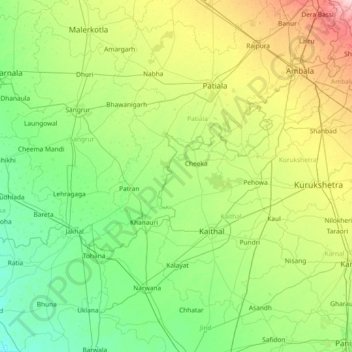
Name: Sangrūr topographic map, elevation, terrain.
Location: Sangrūr, Kaithal, Haryana, Índia (29.36000 75.61000 30.64000 76.89000)
Average elevation: 243 m
Minimum elevation: 211 m
Maximum elevation: 358 m
Other topographic maps
Click on a map to view its topography, its elevation and its terrain.
Palm Spring
Palm Spring, Sector 54, Gurugram, Gurgaon, Haryana, India
Average elevation: 253 m