
Bangweulu Wetlands topographic map
Interactive map
Click on the map to display elevation.
About this map
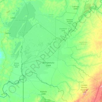
Name: Bangweulu Wetlands topographic map, elevation, terrain.
Location: Bangweulu Wetlands, Luapula Province, Zambia (-12.53746 29.29453 -10.80859 31.05013)
Average elevation: 1,207 m
Minimum elevation: 1,119 m
Maximum elevation: 1,737 m
Other topographic maps
Click on a map to view its topography, its elevation and its terrain.
Mwense
Zambia > Luapula Province > Mwense
Mwense, Luapula Province, P.O BOX 760001 MWENSE, Zambia
Average elevation: 990 m
Lake Bangweulu
Lake Bangweulu, Luapula Province, Zambia
Average elevation: 1,172 m