
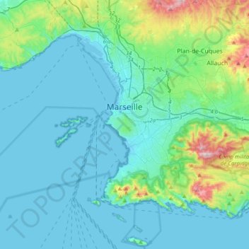
Marseille topographic map
Interactive map
Click on the map to display elevation.
About this map
Name: Marseille topographic map, elevation, terrain.
Average elevation: 94 m
Minimum elevation: -5 m
Maximum elevation: 637 m
Marseille est une ville très accidentée, avec des rues parfois très pentues. le quartier le plus haut de Marseille, Les Trois-Lucs (12e arrondissement), culmine à 242 m d'altitude. Le point le plus élevé du territoire marseillais est le sommet de l'Étoile à 652 m dans le massif du même nom.
Other topographic maps
Click on a map to view its topography, its elevation and its terrain.
Allauch
France > Provence-Alpes-Côte d'Azur > Bouches-du-Rhône
Allauch, Marseille, Bouches-du-Rhône, Provence-Alpes-Côte d'Azur, France métropolitaine, 13190, France
Average elevation: 280 m
Salon-de-Provence
France > Provence-Alpes-Côte d'Azur > Bouches-du-Rhône
Salon-de-Provence, Aix-en-Provence, Bouches-du-Rhône, Provence-Alpes-Côte d'Azur, France métropolitaine, 13300, France
Average elevation: 119 m
Saint-Martin-de-Crau
France > Provence-Alpes-Côte d'Azur > Bouches-du-Rhône
Saint-Martin-de-Crau, Arles, Bouches-du-Rhône, Provence-Alpes-Côte d'Azur, France métropolitaine, 13310, France
Average elevation: 24 m
Istres
France > Provence-Alpes-Côte d'Azur > Bouches-du-Rhône
Istres, Bouches-du-Rhône, Provence-Alpes-Côte d'Azur, France métropolitaine, France
Average elevation: 33 m
Trets
France > Provence-Alpes-Côte d'Azur > Bouches-du-Rhône
Trets, Aix-en-Provence, Bouches-du-Rhône, Provence-Alpes-Côte d'Azur, France métropolitaine, 13530, France
Average elevation: 349 m
Ensuès-la-Redonne
France > Provence-Alpes-Côte d'Azur > Bouches-du-Rhône
Ensuès-la-Redonne, Istres, Bouches-du-Rhône, Provence-Alpes-Côte d'Azur, France métropolitaine, 13820, France
Average elevation: 97 m
Berre-l'Étang
France > Provence-Alpes-Côte d'Azur > Bouches-du-Rhône
Berre-l'Étang, Istres, Bouches-du-Rhône, Provence-Alpes-Côte d'Azur, France métropolitaine, 13130, France
Average elevation: 38 m
Port-Saint-Louis-du-Rhône
France > Provence-Alpes-Côte d'Azur > Bouches-du-Rhône
Port-Saint-Louis-du-Rhône, Istres, Bouches-du-Rhône, Provence-Alpes-Côte d'Azur, France métropolitaine, 13230, France
Average elevation: 0 m
Port-de-Bouc
France > Provence-Alpes-Côte d'Azur > Bouches-du-Rhône
Port-de-Bouc, Istres, Bouches-du-Rhône, Provence-Alpes-Côte d'Azur, France métropolitaine, 13110, France
Average elevation: 12 m
Montagne Sainte-Victoire
France > Provence-Alpes-Côte d'Azur > Bouches-du-Rhône > Vauvenargues
Montagne Sainte-Victoire, Vauvenargues, Aix-en-Provence, Bouches-du-Rhône, Provence-Alpes-Côte d'Azur, France métropolitaine, 13126, France
Average elevation: 451 m
La Destrousse
France > Provence-Alpes-Côte d'Azur > Bouches-du-Rhône > La Destrousse
La Destrousse, Marseille, Bouches-du-Rhône, Provence-Alpes-Côte d'Azur, France métropolitaine, 13112, France
Average elevation: 241 m
Saint-Tronc
France > Provence-Alpes-Côte d'Azur > Bouches-du-Rhône > Marseille
Saint-Tronc, 10e Arrondissement, Marseille, Bouches-du-Rhône, Provence-Alpes-Côte d'Azur, France métropolitaine, 13010, France
Average elevation: 93 m
Peyrolles-en-Provence
France > Provence-Alpes-Côte d'Azur > Bouches-du-Rhône > Peyrolles-en-Provence
Peyrolles-en-Provence, Aix-en-Provence, Bouches-du-Rhône, Provence-Alpes-Côte d'Azur, France métropolitaine, 13860, France
Average elevation: 332 m
Château Saint-Antoine
France > Provence-Alpes-Côte d'Azur > Bouches-du-Rhône > Marseille
Château Saint-Antoine, Boulevard Jules Sebastianelli, Saint-Menet, 11e Arrondissement, Marseille, Bouches-du-Rhône, Provence-Alpes-Côte d'Azur, France métropolitaine, 13011, France
Average elevation: 112 m
Venelles
France > Provence-Alpes-Côte d'Azur > Bouches-du-Rhône > Venelles
Venelles, Aix-en-Provence, Bouches-du-Rhône, Provence-Alpes-Côte d'Azur, France métropolitaine, 13770, France
Average elevation: 349 m
Salin-de-Giraud
France > Provence-Alpes-Côte d'Azur > Bouches-du-Rhône > Arles
Salin-de-Giraud, Arles, Bouches-du-Rhône, Provence-Alpes-Côte d'Azur, France métropolitaine, 13129, France
Average elevation: 0 m
Cassis
France > Provence-Alpes-Côte d'Azur > Bouches-du-Rhône > Cassis
Cassis, Marseille, Bouches-du-Rhône, Provence-Alpes-Côte d'Azur, France métropolitaine, 13260, France
Average elevation: 150 m
La Ciotat
France > Provence-Alpes-Côte d'Azur > Bouches-du-Rhône > La Ciotat > La Ciotat
La Ciotat, Marseille, Bouches-du-Rhône, Provence-Alpes-Côte d'Azur, France métropolitaine, 13600, France
Average elevation: 57 m
Fontvieille
France > Provence-Alpes-Côte d'Azur > Bouches-du-Rhône > Fontvieille
Fontvieille, Arles, Bouches-du-Rhône, Provence-Alpes-Côte d'Azur, France métropolitaine, 13990, France
Average elevation: 47 m
Saint-Rémy-de-Provence
France > Provence-Alpes-Côte d'Azur > Bouches-du-Rhône
Saint-Rémy-de-Provence, Arles, Bouches-du-Rhône, Provence-Alpes-Côte d'Azur, France métropolitaine, 13210, France
Average elevation: 100 m
Martigues
France > Provence-Alpes-Côte d'Azur > Bouches-du-Rhône
Martigues, Istres, Bouches-du-Rhône, Provence-Alpes-Côte d'Azur, France métropolitaine, France
Average elevation: 35 m
Aubagne
France > Provence-Alpes-Côte d'Azur > Bouches-du-Rhône
Aubagne, Marseille, Bouches-du-Rhône, Provence-Alpes-Côte d'Azur, France métropolitaine, 13400, France
Average elevation: 219 m
Les Baux-de-Provence
France > Provence-Alpes-Côte d'Azur > Bouches-du-Rhône
Les Baux-de-Provence, Arles, Bouches-du-Rhône, Provence-Alpes-Côte d'Azur, France métropolitaine, 13520, France
Average elevation: 138 m
Bon-Secours
France > Provence-Alpes-Côte d'Azur > Bouches-du-Rhône > Marseille
Bon-Secours, 14e Arrondissement, Marseille, Bouches-du-Rhône, Provence-Alpes-Côte d'Azur, France métropolitaine, 13014, France
Average elevation: 46 m
Vitrolles
France > Provence-Alpes-Côte d'Azur > Bouches-du-Rhône
Vitrolles, Istres, Bouches-du-Rhône, Provence-Alpes-Côte d'Azur, France métropolitaine, 13127, France
Average elevation: 80 m
Marignane
France > Provence-Alpes-Côte d'Azur > Bouches-du-Rhône
Marignane, Istres, Bouches-du-Rhône, Provence-Alpes-Côte d'Azur, France métropolitaine, 13700, France
Average elevation: 24 m