Geolocate

El Alamein topographic map

Interactive map

Click on the map to display elevation.

About this map

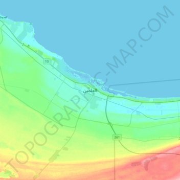
Name: El Alamein topographic map, elevation, terrain.

Location: El Alamein, Matruh, Egypt (30.67394 28.78927 30.99394 29.10927)

Average elevation: 19 m

Minimum elevation: -3 m

Maximum elevation: 101 m

Other topographic maps

Click on a map to view its topography, its elevation and its terrain.

Qattara Depression

Egypt > Matruh

Qattara Depression, Matruh, Egypt

Average elevation: -75 m

Al Daba‘ a

Egypt > Matruh

Al Daba‘ a, Matruh, Egypt

Average elevation: 29 m

Ras Alem Ghomed

Egypt > Matruh

Ras Alem Ghomed, Matruh, Egypt

Average elevation: 10 m

Cascada

Egypt > Matruh

Cascada, Matruh, Egypt

Average elevation: 6 m

مراسي

Egypt > Matruh

مراسي, Matruh, 51732, Egypt

Average elevation: 7 m

Siwa Oasis

Egypt > Matruh > Siwa Oasis

Siwa Oasis, Matruh, Egypt

Average elevation: -6 m

Siwa Oasis

Egypt > Matruh

Siwa Oasis, Matruh, Egypt

Average elevation: 30 m

Marsa Matruh

Egypt > Matruh

Marsa Matruh, Matruh, 51511, Egypt

Average elevation: 37 m