
Corinth topographic map
Interactive map
Click on the map to display elevation.
About this map
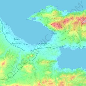
Name: Corinth topographic map, elevation, terrain.
Average elevation: 185 m
Minimum elevation: -3 m
Maximum elevation: 1,356 m
Other topographic maps
Click on a map to view its topography, its elevation and its terrain.
Ancient Korinthos
Greece > Peloponnese, Western Greece and the Ionian > Corinthia Regional Unit > Municipal Unit of Corinth
Ancient Korinthos, Municipal Unit of Corinth, Municipality of Corinth, Corinthia Regional Unit, Peloponnese Region, Peloponnese, Western Greece and the Ionian, 200 07, Greece
Average elevation: 101 m
Municipal Unit of Velos
Greece > Peloponnese, Western Greece and the Ionian > Corinthia Regional Unit
Municipal Unit of Velos, Municipality of Velo and Vocha, Corinthia Regional Unit, Peloponnese Region, Peloponnese, Western Greece and the Ionian, 200 02, Greece
Average elevation: 276 m
Velo
Greece > Peloponnese, Western Greece and the Ionian > Corinthia Regional Unit > Municipal Unit of Velos
Velo, Municipal Unit of Velos, Municipality of Velo and Vocha, Corinthia Regional Unit, Peloponnese Region, Peloponnese, Western Greece and the Ionian, 200 02, Greece
Average elevation: 50 m
Municipality of Nemea
Greece > Peloponnese, Western Greece and the Ionian > Corinthia Regional Unit
Municipality of Nemea, Corinthia Regional Unit, Peloponnese Region, Peloponnese, Western Greece and the Ionian, 205 00, Greece
Average elevation: 461 m
Municipal Unit of Loutraki - Perachora
Greece > Peloponnese, Western Greece and the Ionian > Corinthia Regional Unit
Municipal Unit of Loutraki - Perachora, Loutraki-Perachora-Agioi Theodoroi Municipality, Corinthia Regional Unit, Peloponnese Region, Peloponnese, Western Greece and the Ionian, Greece
Average elevation: 170 m
Municipal Unit of Sikyona
Greece > Peloponnese, Western Greece and the Ionian > Corinthia Regional Unit
Municipal Unit of Sikyona, Municipality of Sikyona, Corinthia Regional Unit, Peloponnese Region, Peloponnese, Western Greece and the Ionian, Greece
Average elevation: 478 m
Γεράνεια (Λουτρακίου-Περαχώρας)
Greece > Peloponnese, Western Greece and the Ionian > Corinthia Regional Unit > Municipal Unit of Loutraki - Perachora
Γεράνεια (Λουτρακίου-Περαχώρας), Municipal Unit of Loutraki - Perachora, Loutraki-Perachora-Agioi Theodoroi Municipality, Corinthia Regional Unit, Peloponnese Region, Peloponnese, Western Greece and the Ionian, 203 00, Greece
Average elevation: 390 m