
Xhariep District Municipality topographic map
Interactive map
Click on the map to display elevation.
About this map
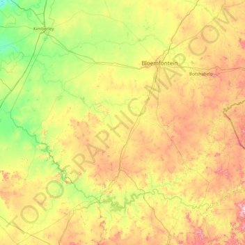
Name: Xhariep District Municipality topographic map, elevation, terrain.
Location: Xhariep District Municipality, Free State, RSA (-30.69408 24.34662 -28.82826 27.41033)
Average elevation: 1,371 m
Minimum elevation: 1,010 m
Maximum elevation: 2,371 m
Other topographic maps
Click on a map to view its topography, its elevation and its terrain.
Matjhabeng Local Municipality
RSA > Free State > Matjhabeng Local Municipality
Matjhabeng Local Municipality, Lejweleputswa District Municipality, Free State, RSA
Average elevation: 1,376 m
Setsoto Local Municipality
RSA > Free State > Setsoto Local Municipality
Setsoto Local Municipality, Thabo Mofutsanyana District Municipality, Free State, 9730, RSA
Average elevation: 1,553 m