
Kofu topographic map
Interactive map
Click on the map to display elevation.
About this map
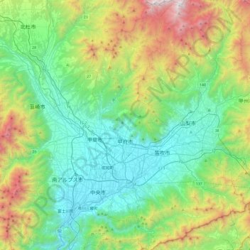
Name: Kofu topographic map, elevation, terrain.
Location: Kofu, Yamanashi Prefecture, Chubu Region, Japan (35.50187 138.52356 35.87588 138.66125)
Average elevation: 865 m
Minimum elevation: 228 m
Maximum elevation: 2,577 m
Other topographic maps
Click on a map to view its topography, its elevation and its terrain.
湊入船町
Japan > Chubu Region > Toyama > 湊入船町
湊入船町, Toyama, Toyama Prefecture, Chubu Region, 930-0001, Japan
Average elevation: 13 m
Minamikoma District
Nanbu, Minamikoma District, Yamanashi Prefecture, Chubu Region, Japan
Average elevation: 641 m
Yamanouchi
Japan > Chubu Region > Yamanouchi
Yamanouchi, Shimotakai County, Nagano Prefecture, Chubu Region, 3810401, Japan
Average elevation: 726 m