
Erigavo topographic map
Interactive map
Click on the map to display elevation.
About this map
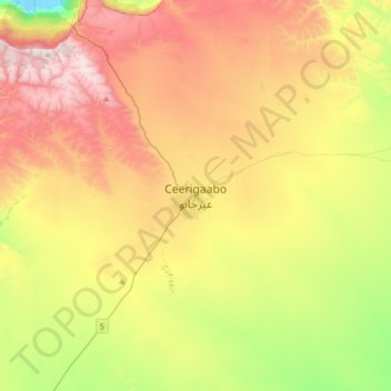
Name: Erigavo topographic map, elevation, terrain.
Location: Erigavo, Erigavo District, Sanaag, Somalia (10.45806 47.21000 10.77806 47.53000)
Average elevation: 1,774 m
Minimum elevation: 1,193 m
Maximum elevation: 2,446 m
10 kilometres or 6.2 miles to the north of the town are the remains of a juniper forest, running along the edge of the escarpment overlooking the Gulf of Aden. The escarpment is approximately 2,000 metres or 6,560 feet above sea level, where the road from Erigavo drops down to the coast. 2 kilometres or 1.2 miles to the west, it rises to the highest point in Somaliland, Shimbiris. A popular local attraction, the summit sits at an elevation of about 2,470 metres or 8,100 feet above sea level. A road also leads up from Erigavo to Daallo mountain. At the mountain's peak, the sea can be observed in addition to the ancient town of Hiis situated nearby.
Other topographic maps
Click on a map to view its topography, its elevation and its terrain.
Sanaag
Somalia > Sanaag > Erigavo District
Sanaag, Erigavo District, Sanaag, Somaliland, Somalia
Average elevation: 856 m