
Parc Georges Henri topographic map
Interactive map
Click on the map to display elevation.
About this map
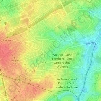
Name: Parc Georges Henri topographic map, elevation, terrain.
Average elevation: 72 m
Minimum elevation: 40 m
Maximum elevation: 100 m
Other topographic maps
Click on a map to view its topography, its elevation and its terrain.
Woluwe
Belgique > Bruxelles-Capitale > Woluwe-Saint-Lambert
Woluwe, Woluwe-Saint-Lambert, Bruxelles-Capitale, 1200, Belgique
Average elevation: 65 m