
Pacific County topographic map
Interactive map
Click on the map to display elevation.
About this map
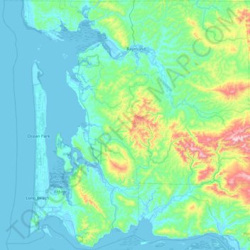
Name: Pacific County topographic map, elevation, terrain.
Location: Pacific County, Washington, United States (46.23500 -124.16741 46.79458 -123.35720)
Average elevation: 124 m
Minimum elevation: -4 m
Maximum elevation: 898 m
Other topographic maps
Click on a map to view its topography, its elevation and its terrain.
Artic
United States > Washington > Grays Harbor County
Artic, Grays Harbor County, Washington, United States
Average elevation: 75 m
Lake Wallula
United States > Washington > Benton County > Richland
Lake Wallula, Richland, Benton County, Washington, 99363, United States
Average elevation: 268 m
Skamania County
Skamania County, Washington, United States
Average elevation: 771 m
Mount Rainier
United States > Washington > Pierce County
Mount Rainier, Pierce County, Washington, United States
Average elevation: 3,912 m