
New York topographic map
Interactive map
Click on the map to display elevation.
About this map
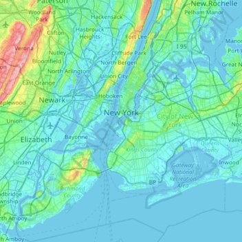
Name: New York topographic map, elevation, terrain.
Location: New York, United States (40.47658 -74.25884 40.91763 -73.70023)
Average elevation: 19 m
Minimum elevation: -6 m
Maximum elevation: 207 m
The city's land has been altered substantially by human intervention, with considerable land reclamation along the waterfronts since Dutch colonial times; reclamation is most prominent in Lower Manhattan, with developments such as Battery Park City in the 1970s and 1980s. Some of the natural relief in topography has been evened out, especially in Manhattan.
Other topographic maps
Click on a map to view its topography, its elevation and its terrain.
Town of Ticonderoga
United States > New York > Essex County
Town of Ticonderoga, Essex County, New York, 12883, United States
Average elevation: 169 m
Hoffmeister
United States > New York > Hamilton County
Hoffmeister, Town of Morehouse, Hamilton County, New York, 13353, United States
Average elevation: 601 m
Hamilton County
Hamilton County, New York, United States
Average elevation: 574 m
Armonk
United States > New York > Westchester County
Armonk, Town of North Castle, Westchester County, New York, 10504, United States
Average elevation: 156 m
Town of Arietta
United States > New York > Hamilton County
Town of Arietta, Hamilton County, New York, United States
Average elevation: 599 m
Bouckville
United States > New York > Madison County
Bouckville, Town of Madison, Madison County, New York, 13310, United States
Average elevation: 393 m
Arctic
United States > New York > Delaware County > Town of Masonville
Arctic, Town of Masonville, Delaware County, New York, United States
Average elevation: 558 m
Village of Black River
United States > New York > Jefferson County
Village of Black River, Town of Le Ray, Jefferson County, New York, United States
Average elevation: 193 m
Village of Delhi
United States > New York > Delaware County
Village of Delhi, Town of Delhi, Delaware County, New York, United States
Average elevation: 526 m
Bloomville
United States > New York > Delaware County
Bloomville, Town of Kortright, Delaware County, New York, United States
Average elevation: 519 m
Shelter Island
United States > New York > Suffolk County
Shelter Island, Town of Shelter Island, Suffolk County, New York, United States
Average elevation: 4 m
Town of Smithtown
United States > New York > Suffolk County
Town of Smithtown, Suffolk County, New York, United States
Average elevation: 21 m
Waverly Glen Park
United States > New York > Tioga County > Waverly
Waverly Glen Park, Waverly, Town of Barton, Tioga County, New York, United States
Average elevation: 295 m
Town of Wallkill
United States > New York > Orange County
Town of Wallkill, Orange County, New York, United States
Average elevation: 171 m
Heath Grove
United States > New York > Town of Otisco > Heath Grove
Heath Grove, Town of Otisco, Onondaga County, New York, 13110, United States
Average elevation: 294 m
Newtonville
United States > New York > Town of Colonie > Newtonville
Newtonville, Town of Colonie, Albany County, New York, 12128, United States
Average elevation: 97 m
West Bangor
United States > New York > West Bangor
West Bangor, Franklin County, New York, 12966, United States
Average elevation: 232 m
New York County
United States > New York > New York
New York County, New York, United States
Average elevation: 16 m
Suffolk County
Suffolk County, New York, United States
Average elevation: 36 m