
Elmore County topographic map
Interactive map
Click on the map to display elevation.
About this map
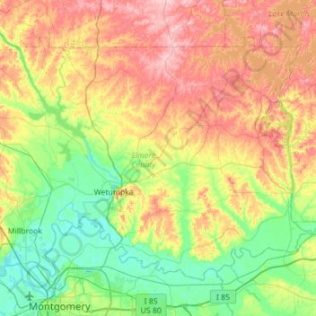
Name: Elmore County topographic map, elevation, terrain.
Location: Elmore County, Alabama, United States (32.40603 -86.41328 32.76930 -85.85312)
Average elevation: 113 m
Minimum elevation: 38 m
Maximum elevation: 235 m
Other topographic maps
Click on a map to view its topography, its elevation and its terrain.
Spring Creek
United States > Alabama > Lawrence County
Spring Creek, Lawrence County, Alabama, United States
Average elevation: 177 m
Duke
United States > Alabama > Calhoun County > Duke
Duke, Calhoun County, Alabama, 36279, United States
Average elevation: 184 m
Adger
United States > Alabama > Adger
Adger, Jefferson County, Alabama, United States
Average elevation: 153 m