
Isle of Arran topographic map
Interactive map
Click on the map to display elevation.
About this map
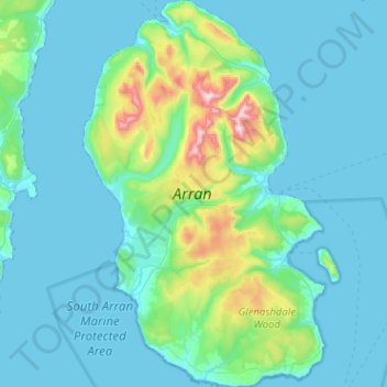
Name: Isle of Arran topographic map, elevation, terrain.
Location: Isle of Arran, North Ayrshire, Scotland, United Kingdom (55.43377 -5.39702 55.72122 -5.07897)
Average elevation: 98 m
Minimum elevation: -1 m
Maximum elevation: 853 m
The island has three endemic species of tree, the Arran whitebeams. These trees are the Scottish or Arran whitebeam (Sorbus arranensis), the bastard mountain ash or cut-leaved whitebeam (Sorbus pseudofennica) and the Catacol whitebeam (Sorbus pseudomeinichii). If rarity is measured by numbers alone they are amongst the most endangered tree species in the world. The trees grow in Glen Diomhan off Glen Catacol which was formerly a National Nature Reserve. Although this designation was removed in 2011 the area continues to form part of a designated Site of Special Scientific Interest (SSSI), and is monitored by staff from NatureScot. Only 236 Sorbus pseudofennica and 283 Sorbus arranensis were recorded as mature trees in 1980. They are typically trees of the mountain slopes, close to the tree line. However, they will grow at lower altitudes, and are being preserved within Brodick Country Park.
Other topographic maps
Click on a map to view its topography, its elevation and its terrain.
Torbeg
United Kingdom > Scotland > North Ayrshire
Torbeg, North Ayrshire, Scotland, KA27 8HE, United Kingdom
Average elevation: 40 m
Kilbirnie
United Kingdom > Scotland > North Ayrshire
Kilbirnie, North Ayrshire, Scotland, KA25 7BY, United Kingdom
Average elevation: 121 m
Auchentiber
United Kingdom > Scotland > North Ayrshire
Auchentiber, North Ayrshire, Scotland, KA13 7RR, United Kingdom
Average elevation: 82 m
Barrmill
United Kingdom > Scotland > North Ayrshire
Barrmill, North Ayrshire, Scotland, KA15 1HP, United Kingdom
Average elevation: 100 m
Brodick
United Kingdom > Scotland > North Ayrshire
Brodick, North Ayrshire, Scotland, KA27 8AL, United Kingdom
Average elevation: 56 m
Seamill
United Kingdom > Scotland > North Ayrshire
Seamill, North Ayrshire, Scotland, KA23 9NB, United Kingdom
Average elevation: 35 m
South Kiscadale
United Kingdom > Scotland > North Ayrshire > Whiting Bay
South Kiscadale, Whiting Bay, North Ayrshire, Scotland, KA27 8QS, United Kingdom
Average elevation: 112 m
Kilpatrick
United Kingdom > Scotland > North Ayrshire > Blackwaterfoot
Kilpatrick, Blackwaterfoot, North Ayrshire, Scotland, KA27 8EY, United Kingdom
Average elevation: 68 m
Auchagallon
United Kingdom > Scotland > North Ayrshire
Auchagallon, North Ayrshire, Scotland, KA27 8DZ, United Kingdom
Average elevation: 54 m
SUDs
United Kingdom > Scotland > North Ayrshire > Saltcoats
SUDs, Saltcoats, North Ayrshire, Scotland, United Kingdom
Average elevation: 48 m
Drakemyre
United Kingdom > Scotland > North Ayrshire > Dalry
Drakemyre, Dalry, North Ayrshire, Scotland, KA24 5JE, United Kingdom
Average elevation: 67 m
Largs
United Kingdom > Scotland > North Ayrshire
Largs, North Ayrshire, Scotland, KA30 8AA, United Kingdom
Average elevation: 110 m
West Kilbride
United Kingdom > Scotland > North Ayrshire
West Kilbride, North Ayrshire, Scotland, KA23 9AP, United Kingdom
Average elevation: 67 m
Caaf Water
United Kingdom > Scotland > North Ayrshire > Dalry
Caaf Water, Dalry, North Ayrshire, Scotland, KA24 5HJ, United Kingdom
Average elevation: 88 m
Fairlie Moor
United Kingdom > Scotland > North Ayrshire > Fairlie
Fairlie Moor, Fairlie, North Ayrshire, Scotland, United Kingdom
Average elevation: 174 m
Kilwinning
United Kingdom > Scotland > North Ayrshire
Kilwinning, North Ayrshire, Scotland, KA13 6AD, United Kingdom
Average elevation: 36 m
Glengarnock
United Kingdom > Scotland > North Ayrshire
Glengarnock, North Ayrshire, Scotland, KA14 3AF, United Kingdom
Average elevation: 59 m
Beith
United Kingdom > Scotland > North Ayrshire
Beith, North Ayrshire, Scotland, KA15 1BS, United Kingdom
Average elevation: 92 m
Ardrossan
United Kingdom > Scotland > North Ayrshire
Ardrossan, North Ayrshire, Scotland, KA22 8BS, United Kingdom
Average elevation: 21 m
Butt
United Kingdom > Scotland > North Ayrshire > Millhill > Butt
Butt, Millhill, North Ayrshire, Scotland, KA27 8HQ, United Kingdom
Average elevation: 139 m
Shedog
United Kingdom > Scotland > North Ayrshire > Shedog
Shedog, North Ayrshire, Scotland, KA27 8EW, United Kingdom
Average elevation: 93 m
Irvine
United Kingdom > Scotland > North Ayrshire
Irvine, North Ayrshire, Scotland, KA12 0AX, United Kingdom
Average elevation: 13 m
Torranyard
United Kingdom > Scotland > North Ayrshire > Torranyard
Torranyard, North Ayrshire, Scotland, KA13 7RD, United Kingdom
Average elevation: 58 m
Lochranza
United Kingdom > Scotland > North Ayrshire
Lochranza, North Ayrshire, Scotland, KA27 8HL, United Kingdom
Average elevation: 99 m
Saltcoats
United Kingdom > Scotland > North Ayrshire
Saltcoats, North Ayrshire, Scotland, KA21 5EL, United Kingdom
Average elevation: 18 m
Dreghorn
United Kingdom > Scotland > North Ayrshire
Dreghorn, North Ayrshire, Scotland, KA11 4AH, United Kingdom
Average elevation: 19 m
Blackwaterfoot
United Kingdom > Scotland > North Ayrshire
Blackwaterfoot, North Ayrshire, Scotland, KA27 8ET, United Kingdom
Average elevation: 32 m
Portencross
United Kingdom > Scotland > North Ayrshire
Portencross, North Ayrshire, Scotland, KA23 9QA, United Kingdom
Average elevation: 10 m
Dalry
United Kingdom > Scotland > North Ayrshire
Dalry, North Ayrshire, Scotland, KA24 5AW, United Kingdom
Average elevation: 97 m
Lamlash
United Kingdom > Scotland > North Ayrshire
Lamlash, North Ayrshire, Scotland, KA27 8NA, United Kingdom
Average elevation: 79 m
Shiskine
United Kingdom > Scotland > North Ayrshire
Shiskine, North Ayrshire, Scotland, KA27 8EG, United Kingdom
Average elevation: 87 m
Millport
United Kingdom > Scotland > North Ayrshire > Millport
Millport, North Ayrshire, Scotland, KA28 0BE, United Kingdom
Average elevation: 11 m