
Busuanga topographic map
Interactive map
Click on the map to display elevation.
About this map
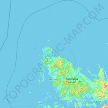
Name: Busuanga topographic map, elevation, terrain.
Location: Busuanga, Palawan, Mimaropa, 5317, Philippines (11.95889 119.64513 12.60692 120.15842)
Average elevation: 12 m
Minimum elevation: -1 m
Maximum elevation: 454 m
Other topographic maps
Click on a map to view its topography, its elevation and its terrain.
Puerto Princesa
Philippines > Palawan > Puerto Princesa
Puerto Princesa, Palawan, Mimaropa, 5300, Philippines
Average elevation: 92 m
Taytay
Philippines > Palawan > Taytay
Taytay, Palawan, Mimaropa, 5312, Philippines
Average elevation: 54 m
Cagdanao Island
Cagdanao Island, Palawan, Mimaropa, Philippines
Average elevation: 1 m