
Forest Park topographic map
Interactive map
Click on the map to display elevation.
About this map
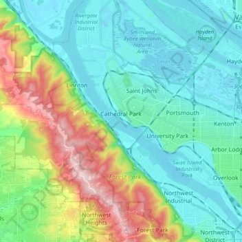
Name: Forest Park topographic map, elevation, terrain.
Average elevation: 91 m
Minimum elevation: -4 m
Maximum elevation: 358 m
Other topographic maps
Click on a map to view its topography, its elevation and its terrain.
Portland Downtown
Portland Downtown, Portland, Multnomah County, Oregon, USA
Average elevation: 50 m
Pearl District
Pearl District, Portland, Multnomah County, Oregon, USA
Average elevation: 25 m
Hosford-Abernethy
Hosford-Abernethy, Portland, Multnomah County, Oregon, USA
Average elevation: 26 m