
Paro District topographic map
Interactive map
Click on the map to display elevation.
About this map
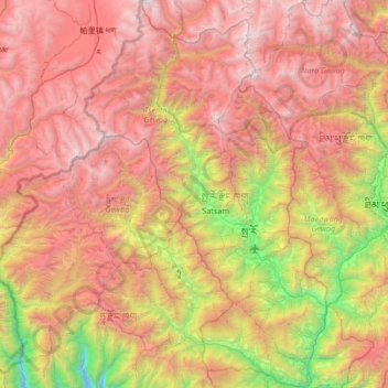
Name: Paro District topographic map, elevation, terrain.
Location: Paro District, Bhutan (27.18834 89.12806 27.78384 89.54903)
Average elevation: 3,704 m
Minimum elevation: 1,646 m
Maximum elevation: 5,692 m
Other topographic maps
Click on a map to view its topography, its elevation and its terrain.
Thimphu
Bhutan > Thimphu District > Chang Gewog
Thimphu, Chang Gewog, Thimphu, Thimphu District, 11001, Bhutan
Average elevation: 3,121 m