
Parc régional Montagne du Diable topographic map
Interactive map
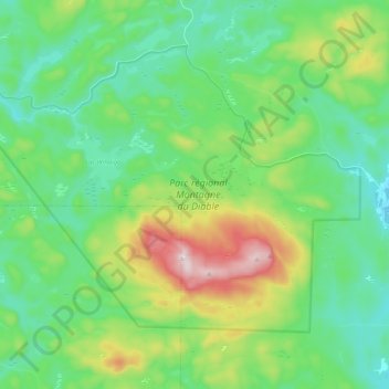
Click on the map to display elevation.
About this map
Name: Parc régional Montagne du Diable topographic map, elevation, terrain.
Average elevation: 381 m
Minimum elevation: 237 m
Maximum elevation: 762 m
Other topographic maps
Click on a map to view its topography, its elevation and its terrain.
Lac Piscatosine
Canada > Québec > Ferme-Neuve
Lac Piscatosine, Chemin du Piscatosine, Ferme-Neuve, Antoine-Labelle, Laurentides, Québec, J0W 1C0, Canada
Average elevation: 218 m
Branche Papineau
Canada > Québec > Ferme-Neuve
Branche Papineau, Ferme-Neuve, Antoine-Labelle, Laurentides, Québec, Canada
Average elevation: 312 m
Mont Sir-Wilfrid
Canada > Québec > Ferme-Neuve
Mont Sir-Wilfrid, Ferme-Neuve, Antoine-Labelle, Laurentides, Québec, Canada
Average elevation: 605 m