
Agusan del Norte topographic map
Interactive map
Click on the map to display elevation.
About this map
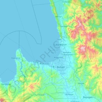
Name: Agusan del Norte topographic map, elevation, terrain.
Location: Agusan del Norte, Caraga, Philippines (8.70264 125.19959 9.49872 125.78874)
Average elevation: 230 m
Minimum elevation: 0 m
Maximum elevation: 1,888 m
Other topographic maps
Click on a map to view its topography, its elevation and its terrain.
Barangay Bayanihan
Philippines > Agusan del Norte > Barangay Bayanihan
Barangay Bayanihan, Agusan del Norte, Caraga, 8600`, Philippines
Average elevation: 5 m
Butuan
Philippines > Agusan del Norte > Butuan
Butuan, Agusan del Norte, Caraga, 8600`, Philippines
Average elevation: 104 m