
Chaiyaphum Province topographic map
Interactive map
Click on the map to display elevation.
About this map
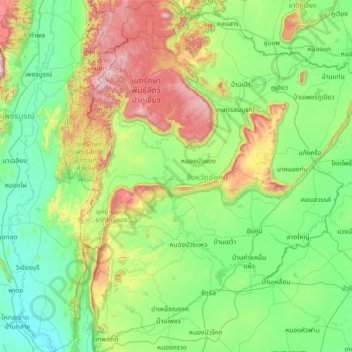
Name: Chaiyaphum Province topographic map, elevation, terrain.
Location: Chaiyaphum Province, Thailand (15.33301 101.32249 16.70499 102.46138)
Average elevation: 317 m
Minimum elevation: 52 m
Maximum elevation: 1,316 m
The province is bisected by the Phetchabun mountain range, with the highest elevation in the province at 1,222 m. The east of the province is part of the Khorat Plateau.
Other topographic maps
Click on a map to view its topography, its elevation and its terrain.
Nam Nao National Park
Thailand > Chaiyaphum Province
Nam Nao National Park, Chaiyaphum Province, Thailand
Average elevation: 676 m
Thep Sathit
Thailand > Chaiyaphum Province > Thep Sathit
Thep Sathit, Chaiyaphum Province, Thailand
Average elevation: 294 m