
County Carlow topographic map
Interactive map
Click on the map to display elevation.
About this map
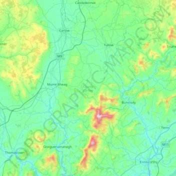
Name: County Carlow topographic map, elevation, terrain.
Location: County Carlow, Leinster, Ireland (52.46359 -7.10794 52.91802 -6.50494)
Average elevation: 126 m
Minimum elevation: 0 m
Maximum elevation: 789 m
The soils of the county are mostly derived from glacial till, rather than solid bedrock geology. These typically consist of a mix of clay, sand and gravel. Occasionally glacial melt-water would form a long ridge of sand and gravel known as an esker. One such example is preserved within the county and is a proposed natural heritage area, referred to as the Ballymoon Esker. The north of the county is generally flat, while central and southern Carlow are characterised by an undulating to rolling topography which becomes progressively hillier towards the south and east. The Blackstairs Mountains are the highest and most extensive upland area, with Mount Leinster rising to 794 m (2,605 ft), making it the highest point in both Carlow and Wexford and the seventh highest county top in Ireland.
Other topographic maps
Click on a map to view its topography, its elevation and its terrain.
The Municipal District of Fermoy
The Municipal District of Fermoy, County Cork, Munster, Ireland
Average elevation: 145 m
Sligo Municipal Borough District
Sligo Municipal Borough District, County Sligo, Connacht, Ireland
Average elevation: 87 m
Killarney
Killarney, Killarney Municipal District, County Kerry, Munster, Ireland
Average elevation: 57 m
Dún Laoghaire-Rathdown
Dún Laoghaire-Rathdown, County Dublin, Leinster, Ireland
Average elevation: 139 m
The Borough District of Wexford
The Borough District of Wexford, County Wexford, Leinster, Ireland
Average elevation: 29 m
Lucan
Ireland > County Dublin > Lucan
Lucan, South Dublin, County Dublin, Leinster, K78 K8F7, Ireland
Average elevation: 59 m
Rush Martello Tower
Rush Martello Tower, Tower Street, Rush, Rush ED, Rush, Fingal, County Dublin, Leinster, K56 ED95, Ireland
Average elevation: 2 m
North Constituency
North Constituency, Dublin, Dublin 1, Leinster, Ireland
Average elevation: 32 m
Dún Laoghaire
Dún Laoghaire, Dún Laoghaire-Rathdown, County Dublin, Leinster, A96 A258, Ireland
Average elevation: 21 m
Lugnaquilla
Lugnaquilla, The Municipal District of Baltinglass, County Wicklow, Leinster, Ireland
Average elevation: 697 m
Cherry Orchard
Cherry Orchard, Merchants Quay E ED, Dublin 8, Dublin, County Dublin, Leinster, Ireland
Average elevation: 25 m
Carrauntoohil
Carrauntoohil, Kenmare Municipal District, County Kerry, Munster, Ireland
Average elevation: 644 m
Rathfarnham Village ED
Rathfarnham Village ED, Rathfarnham, South Dublin, County Dublin, Leinster, DUBLIN 6W, Ireland
Average elevation: 55 m
Wicklow Mountains National Park
Wicklow Mountains National Park, Mullaghcleevaun to Moanbane and Silsean, Glenbride, Lackan, The Municipal District of Baltinglass, County Wicklow, Leinster, Ireland
Average elevation: 324 m
North Bull Island
North Bull Island, Raheny St. Assam ED, Dublin 5, Dublin, County Dublin, Leinster, Ireland
Average elevation: 2 m