
Zhenghua Nature Park topographic map
Interactive map
Click on the map to display elevation.
About this map
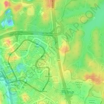
Name: Zhenghua Nature Park topographic map, elevation, terrain.
Location: Zhenghua Nature Park, Bukit Panjang, Northwest, Singapore (1.38454 103.77222 1.38689 103.77437)
Average elevation: 38 m
Minimum elevation: -15 m
Maximum elevation: 76 m
Other topographic maps
Click on a map to view its topography, its elevation and its terrain.
Admiralty Park
Singapore > Northwest > Singapore
Admiralty Park, Woodlands, Singapore, Northwest, Singapore
Average elevation: 19 m
Hindhede Quarry
Hindhede Quarry, Bukit Panjang, Northwest, Singapore
Average elevation: 50 m
Bukit Timah Hill
Bukit Timah Hill, Northwest, 589333, Singapore
Average elevation: 52 m
Sembawang Park
Sembawang Park, Sembawang, Northwest, Singapore
Average elevation: 7 m