
Ubon Ratchathani Province topographic map
Interactive map
Click on the map to display elevation.
About this map
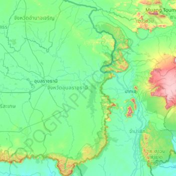
Name: Ubon Ratchathani Province topographic map, elevation, terrain.
Location: Ubon Ratchathani Province, Thailand (14.20957 104.38147 16.09787 105.63681)
Average elevation: 206 m
Minimum elevation: 69 m
Maximum elevation: 1,564 m
Other topographic maps
Click on a map to view its topography, its elevation and its terrain.
Ubon Ratchathani
Thailand > Ubon Ratchathani Province > Ubon Ratchathani
Ubon Ratchathani, Ubon Ratchathani Province, 34000, Thailand
Average elevation: 125 m