
Roi Et Province topographic map
Interactive map
Click on the map to display elevation.
About this map
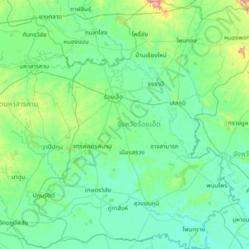
Name: Roi Et Province topographic map, elevation, terrain.
Location: Roi Et Province, Thailand (15.40497 103.29526 16.47277 104.35593)
Average elevation: 146 m
Minimum elevation: 116 m
Maximum elevation: 409 m
Other topographic maps
Click on a map to view its topography, its elevation and its terrain.
บ้านไศลทอง
Thailand > Roi Et Province > Ban Non Si La > Ban Non Muang
บ้านไศลทอง, 2043, Ban Khum Kae, Ban Non Muang, Ban Non Si La, Pho Chai, Roi Et Province, 35130, Thailand
Average elevation: 127 m