
Knoxville topographic map
Interactive map
Click on the map to display elevation.
About this map
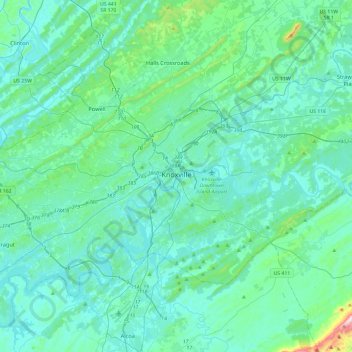
Name: Knoxville topographic map, elevation, terrain.
Average elevation: 307 m
Minimum elevation: 232 m
Maximum elevation: 881 m
According to the United States Census Bureau, the city has a total area of 104.2 square miles (269.8 km2), of which 98.5 square miles (255.2 km2) is land and 5.6 square miles (14.6 km2), or 5.42%, is water. Elevations range from just over 800 feet (240 m) along the riverfront to just over 1,000 feet (300 m) on various hilltops in West Knoxville, with the downtown area resting at just over 900 feet (270 m). High points include Sharp's Ridge in North Knoxville at 1,391 feet (424 m) and Brown Mountain in South Knoxville at 1,260 feet (380 m). House Mountain, the highest point in Knox County at 2,064 feet (629 m), is located east of the city near Mascot.
Other topographic maps
Click on a map to view its topography, its elevation and its terrain.
Dead Horse Lake
United States > Tennessee > Knox County > Knoxville
Dead Horse Lake, Cedar Bluff, Knoxville, Knox County, East Tennessee, Tennessee, United States
Average elevation: 296 m
Farragut
United States > Tennessee > Knox County
Farragut, Knox County, East Tennessee, Tennessee, 37934, United States
Average elevation: 281 m
Whittle Springs
United States > Tennessee > Knox County > Knoxville
Whittle Springs, Knoxville, Knox County, East Tennessee, Tennessee, 37917, United States
Average elevation: 311 m
Shannondale
United States > Tennessee > Knox County > Knoxville
Shannondale, Knoxville, Knox County, East Tennessee, Tennessee, 37918, United States
Average elevation: 334 m
Treeville
United States > Tennessee > Knox County
Treeville, Knox County, Tennessee, 37931, United States
Average elevation: 319 m
High Bluff
United States > Tennessee > Knox County
High Bluff, Knox County, Tennessee, United States
Average elevation: 298 m
Knoxville
United States > Tennessee > Knox County > Knoxville
Knoxville, Knox County, Tennessee, 37996-4134, United States
Average elevation: 304 m
Vestal
United States > Tennessee > Knox County > Knoxville > Vestal
Vestal, Knoxville, Knox County, Tennessee, 37920, United States
Average elevation: 284 m
Melton Hill Park
United States > Tennessee > Knox County
Melton Hill Park, Knox County, Tennessee, United States
Average elevation: 269 m