
County Donegal topographic map
Interactive map
Click on the map to display elevation.
About this map
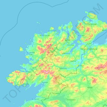
Name: County Donegal topographic map, elevation, terrain.
Location: County Donegal, Ulster, Ireland (54.45905 -8.83471 55.43530 -6.92273)
Average elevation: 74 m
Minimum elevation: -4 m
Maximum elevation: 697 m
The majority of Donegal has a temperate oceanic climate (Köppen climate classification: Cfb), with upland areas in the Derryveagh and Blue Stack ranges classified as oceanic subpolar (Köppen climate classification: Cfc). The county's climate is heavily influenced by the North Atlantic Current. Due to the topography of western Donegal, it receives orographic rainfall, where the air is forced to rise on contact with its mountainous coastline and subsequently cools and condenses, forming clouds. The mountains of Donegal are among the cloudiest places in Ireland, and northern Donegal is the windiest. Irish monthly record wind speeds for March, June, July, September, November and December have all been set at Malin Head. The highest wind speed ever recorded in Donegal was 181 km/h (112 mph) on 16 September 1961, during Hurricane Debbie.
Other topographic maps
Click on a map to view its topography, its elevation and its terrain.
Cork
Ireland > County Cork > Cork
Cork, County Cork, Munster, T12 T997, Ireland
Average elevation: 94 m
Galway City
Galway, Galway City, County Galway, Connacht, H91 YD86, Ireland
Average elevation: 26 m
Comeragh
Comeragh, The Municipal District of Comeragh, County Waterford, Munster, Ireland
Average elevation: 215 m
Ballincollig
Ireland > County Cork > Cork
Ballincollig, Cork, County Cork, Munster, P31 TW88, Ireland
Average elevation: 62 m
Adare
Ireland > County Limerick > The Municipal District of Adare — Rathkeale
Adare, The Municipal District of Adare — Rathkeale, County Limerick, Munster, Ireland
Average elevation: 12 m
Lanesborough
Lanesborough, Ballymahon Municipal District, County Longford, Leinster, Ireland
Average elevation: 41 m
Cordarragh
Cordarragh, Headford ED, Tuam Municipal District, County Galway, Connacht, Ireland
Average elevation: 20 m
Summerhill
Summerhill, Summerhill ED, The Municipal District of Trim, County Meath, Leinster, Ireland
Average elevation: 86 m
Curraghboy
Curraghboy, Rockhill Electoral Division, Athlone Municipal District, County Roscommon, Connacht, N37 EK20, Ireland
Average elevation: 69 m
Kilcurriv Eighter
Kilcurriv Eighter, Killower ED, Tuam Municipal District, County Galway, Connacht, Ireland
Average elevation: 48 m
Cahir
Cahir, The Municipal District of Cahir — Cashel, County Tipperary, Munster, Ireland
Average elevation: 58 m
Mount Lucas
Mount Lucas, Esker ED, The Municipal District of Edenderry, County Offaly, Leinster, R35 XW10, Ireland
Average elevation: 76 m
Lettermore
Lettermore, Lettermore ED, Conamara Municipal District, County Galway, Connacht, Ireland
Average elevation: 8 m
Lough Bane
Lough Bane, Crosskeys ED, The Municipal District of Kells, County Westmeath, County Meath, Leinster, Ireland
Average elevation: 130 m
Broadlough
Broadlough, Ardee Rural ED, The Municipal District of Ardee, County Louth, Leinster, Ireland
Average elevation: 34 m
Moorock
Moorock, Ballycumber ED, The Municipal District of Tullamore, County Offaly, Leinster, Ireland
Average elevation: 64 m
Barnadown
Barnadown, Aghaviller, The Municipal District of Callan — Thomastown, County Kilkenny, Leinster, Ireland
Average elevation: 212 m
Shronowen
Shronowen, Shronowen ED, Listowel Municipal District, County Kerry, Munster, Ireland
Average elevation: 27 m
Pembrokestown
Pembrokestown, Waterford City Metropolitan District, County Waterford, Munster, X91 R6CA, Ireland
Average elevation: 57 m
Callanagh Lower
Callanagh Lower, Drumlumman ED, Ballyjamesduff Municipal District, County Cavan, Ulster, Ireland
Average elevation: 85 m
Gorteennakilla
Gorteennakilla, Youghalarra, The Municipal District of Nenagh, County Tipperary, Munster, Ireland
Average elevation: 57 m
Kiltole
Kiltole, Figart ED, Lifford-Stranorlar Municipal District, County Donegal, Ireland
Average elevation: 49 m
Durrow
Durrow, The Municipal District of Tullamore, County Offaly, Leinster, R35 X865, Ireland
Average elevation: 66 m
Inchigeelagh
Inchigeelagh, Municipal District of Macroom, County Cork, Munster, P12 W864, Ireland
Average elevation: 135 m
Aghafin
Aghafin, Aghafin ED, Boyle Municipal District, County Roscommon, Connacht, Ireland
Average elevation: 50 m
Smithstown
Smithstown, Ballinlough ED, The Municipal District of Kells, County Meath, Leinster, Ireland
Average elevation: 121 m
Cloonmore
Cloonmore, Belclare ED, Tuam Municipal District, County Galway, Connacht, Ireland
Average elevation: 33 m
Ballyhaunis
Ballyhaunis, Claremorris-Swinford Municipal District, County Mayo, Connacht, F35 NF82, Ireland
Average elevation: 87 m
Ballinaclogh
Ballinaclogh, Glenealy ED, The Municipal District of Wicklow, County Wicklow, Leinster, Ireland
Average elevation: 108 m
Priorswood
Ireland > County Dublin > Dublin
Priorswood, Priorswood E Ward 1986, Dublin, County Dublin, Leinster, D17 XV48, Ireland
Average elevation: 42 m
Pollduff
Pollduff, Loughrea Municipal District, County Galway, Connacht, Ireland
Average elevation: 219 m
Ballyboughal
Ballyboughal, Ballyboghil DED 1986, Fingal, County Dublin, Leinster, Ireland
Average elevation: 35 m
Upper Lough Bray
Upper Lough Bray, Powerscourt ED, The Municipal District of Bray, County Wicklow, Leinster, Ireland
Average elevation: 496 m
Yellowmeadows
Yellowmeadows, Clondalkin-Monastery DED 1986, South Dublin, County Dublin, Leinster, Ireland
Average elevation: 59 m
Dawros
Dawros, Banada ED, Ballymote-Tubbercurry Municipal District, County Sligo, Connacht, Ireland
Average elevation: 52 m
Knockawaddra
Knockawaddra, Ballingurteen ED, West Cork, County Cork, Munster, Ireland
Average elevation: 154 m
Dehomad
Dehomad, Clondagad ED, West Clare Municipal District, County Clare, Munster, Ireland
Average elevation: 130 m
Lissycasey
Lissycasey, West Clare Municipal District, County Clare, Munster, Ireland
Average elevation: 101 m
Lissaviron
Lissaviron, Annestown ED, The Municipal District of Comeragh, County Waterford, Munster, Ireland
Average elevation: 60 m