
Allegheny County topographic map
Interactive map
Click on the map to display elevation.
About this map
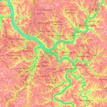
Name: Allegheny County topographic map, elevation, terrain.
Location: Allegheny County, Pennsylvania, United States (40.19434 -80.36087 40.67494 -79.68876)
Average elevation: 325 m
Minimum elevation: 204 m
Maximum elevation: 428 m
Other topographic maps
Click on a map to view its topography, its elevation and its terrain.
Cooper Township
United States > Pennsylvania > Clearfield County
Cooper Township, Clearfield County, Pennsylvania, United States
Average elevation: 456 m
Hegins Township
United States > Pennsylvania > Schuylkill County
Hegins Township, Schuylkill County, Pennsylvania, United States
Average elevation: 326 m
Philadelphia
Philadelphia, Pennsylvania, 19140, United States
Average elevation: 68 m
Lancaster County
Lancaster County, Pennsylvania, United States
Average elevation: 158 m
Carbon County
Carbon County, Pennsylvania, United States
Average elevation: 387 m
Montgomery County
Montgomery County, Pennsylvania, United States
Average elevation: 109 m