
Zermatt topographic map
Interactive map
Click on the map to display elevation.
About this map
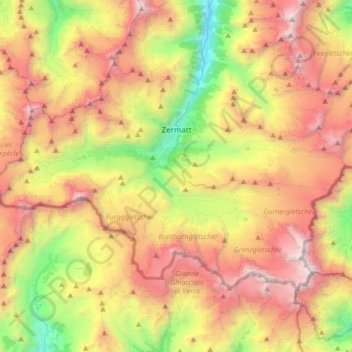
Name: Zermatt topographic map, elevation, terrain.
Location: Zermatt, Visp, Wallis, 3920, Switzerland (45.91670 7.57538 46.06428 7.90870)
Average elevation: 2,921 m
Minimum elevation: 1,406 m
Maximum elevation: 4,619 m
It lies at the upper end of Mattertal at an elevation of 1,620 m (5,310 ft), at the foot of Switzerland's highest peaks. It lies about 10 km (6.2 mi) from the over 3,292 m (10,801 ft) high Theodul Pass bordering Italy.
Other topographic maps
Click on a map to view its topography, its elevation and its terrain.
Saas-Fee
Switzerland > Wallis > Visp
Saas-Fee, Visp, Wallis, 3906, Switzerland
Average elevation: 2,673 m