
Addis Ababa topographic map
Interactive map
Click on the map to display elevation.
About this map
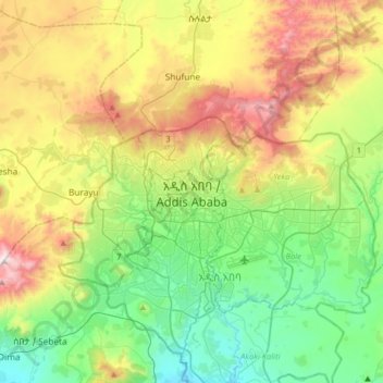
Name: Addis Ababa topographic map, elevation, terrain.
Location: Addis Ababa, Arada, Addis Ababa, 3578, Ethiopia (8.87583 38.59241 9.19583 38.91241)
Average elevation: 2,517 m
Minimum elevation: 2,058 m
Maximum elevation: 3,383 m
Addis Ababa lies at an elevation of 2,355 metres (7,726 ft) and is a grassland biome, located at 9°1′48″N 38°44′24″E / 9.03000°N 38.74000°E / 9.03000; 38.74000. The city lies at the foot of Mount Entoto and forms part of the watershed for the Awash. From its lowest point, around Bole International Airport, at 2,326 metres (7,631 ft) above sea level in the southern periphery, Addis Ababa rises to over 3,000 metres (9,800 ft) in the Entoto Mountains to the north.