
Tijuana topographic map
Interactive map
Click on the map to display elevation.
About this map
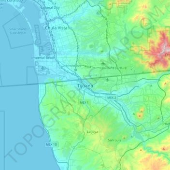
Name: Tijuana topographic map, elevation, terrain.
Average elevation: 203 m
Minimum elevation: -2 m
Maximum elevation: 1,069 m
Housing development in the Tijuana Hills has led to eradication of many seasonal mountain streams. This lack of natural drainage makes places within the city vulnerable to landslides during the rainy season. The varied terrain of Tijuana gives the city elevation extremes that range from sea level to 790 metres (2,590 ft).