
Tongatapu topographic map
Interactive map
Click on the map to display elevation.
About this map
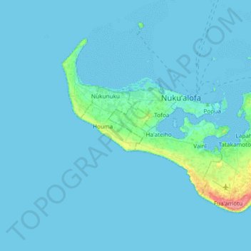
Name: Tongatapu topographic map, elevation, terrain.
Location: Tongatapu, Vahe Hihifo, Tongatapu, Tonga (-21.27316 -175.35651 -21.06249 -175.03143)
Average elevation: 4 m
Minimum elevation: 0 m
Maximum elevation: 70 m
Tongatapu is the main island of the Kingdom of Tonga and site of Tonga’s capital, Nukuʻalofa. It is located in Tonga's southern island group, to which it gives its name, and is the country's most populous island, with 74,611 residents (2016), 70.5% of the national population, on 260 square kilometres (100 square miles). Its maximum elevation is 28 metres (92 feet) above sea level. Tongatapu is Tonga's centre of government and the seat of its monarchy.
Other topographic maps
Click on a map to view its topography, its elevation and its terrain.