
San Juan topographic map
Interactive map
Click on the map to display elevation.
About this map
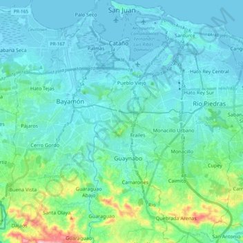
Name: San Juan topographic map, elevation, terrain.
Location: San Juan, Puerto Rico, United States (18.29653 -66.12509 18.47199 -65.99142)
Average elevation: 59 m
Minimum elevation: -3 m
Maximum elevation: 400 m
As with other parts of Puerto Rico and the Caribbean, San Juan is often blanketed by waves of Saharan dust coming from the Sahara across the Atlantic Ocean in Northern Africa. Although beneficial to the tropical environment, these dust storms have recently become hazardous to human health causing haze and overheating in urban areas of the island. Due to San Juan's relatively flat geography, the dust often settles in these flat coastal regions of Puerto Rico as its flow is blocked by the higher altitude Cordillera Central to the south, causing intense episodes of haze to settle for long periods of time, especially during periods of more scarce rainfall. Recent advancements include early warning systems to prepare the population for these intense episodes by both local authorities and the EPA.
Other topographic maps
Click on a map to view its topography, its elevation and its terrain.