
Nakhon Nayok Province topographic map
Interactive map
Click on the map to display elevation.
About this map
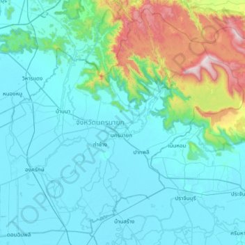
Name: Nakhon Nayok Province topographic map, elevation, terrain.
Location: Nakhon Nayok Province, Thailand (13.96124 100.91360 14.50611 101.51555)
Average elevation: 183 m
Minimum elevation: 0 m
Maximum elevation: 1,320 m
The northern part of the province is in the Sankamphaeng Range, the southern prolongation of the Dong Phaya Yen mountains, with the highest elevation the 1,292-meter-high Yod Khao Kiew. Most of that area is covered by the Khao Yai National Park. The total forest area is 642 km2 (248 sq mi) or 30 percent of provincial area. The central part of the province however is a rather flat river plain formed by the Nakhon Nayok River. The southern part of the province has relatively infertile acidic soil.