
Baltimore topographic map
Interactive map
Click on the map to display elevation.
About this map
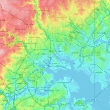
Name: Baltimore topographic map, elevation, terrain.
Location: Baltimore, Maryland, United States (39.19723 -76.71130 39.37200 -76.52968)
Average elevation: 47 m
Minimum elevation: -4 m
Maximum elevation: 158 m
Other topographic maps
Click on a map to view its topography, its elevation and its terrain.
Middle East
United States > Maryland > Baltimore
Middle East, Baltimore, Maryland, United States
Average elevation: 29 m
Urbana
United States > Maryland > Frederick County
Urbana, Frederick County, Maryland, United States
Average elevation: 131 m
Baltimore County
Baltimore County, Maryland, United States
Average elevation: 123 m
Friendship Heights Village
United States > Maryland > Montgomery County > Friendship Heights Village
Friendship Heights Village, Montgomery County, Maryland, United States
Average elevation: 94 m
Phoenix
United States > Maryland > Baltimore County > Phoenix
Phoenix, Baltimore County, Maryland, 21030, United States
Average elevation: 123 m