
Greiz topographic map
Interactive map
Click on the map to display elevation.
About this map
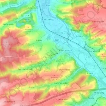
Name: Greiz topographic map, elevation, terrain.
Location: Bad Köstritz, Greiz, Thuringia, Germany (50.90049 11.94940 50.95672 12.04949)
Average elevation: 245 m
Minimum elevation: 173 m
Maximum elevation: 328 m
Other topographic maps
Click on a map to view its topography, its elevation and its terrain.
Geismar
Germany > Thuringia > Landkreis Eichsfeld
Geismar, Ershausen/Geismar, Landkreis Eichsfeld, Thuringia, Germany
Average elevation: 292 m
Lipprechterode
Germany > Thuringia > Lipprechterode
Lipprechterode, Bleicherode, Landkreis Nordhausen, Thuringia, Germany
Average elevation: 281 m