
堺市 topographic map
Interactive map
Click on the map to display elevation.
About this map
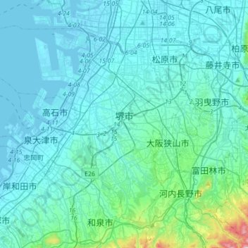
Name: 堺市 topographic map, elevation, terrain.
Location: 堺市, Prefectura de Osaka, 近畿地方, Japón (34.43015 135.31163 34.60833 135.58764)
Average elevation: 62 m
Minimum elevation: -7 m
Maximum elevation: 676 m
Other topographic maps
Click on a map to view its topography, its elevation and its terrain.
琵琶湖
Japón > 近畿地方 > Higashiōmi
琵琶湖, 滋賀県道52号栗見八日市線, Higashiōmi, Prefectura de Shiga, 近畿地方, Japón
Average elevation: 269 m