
Navi Mumbai topographic map
Interactive map
Click on the map to display elevation.
About this map
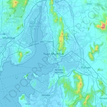
Name: Navi Mumbai topographic map, elevation, terrain.
Location: Navi Mumbai, Thane, Maharashtra, 400706, India (18.87083 72.85985 19.19083 73.17985)
Average elevation: 30 m
Minimum elevation: -4 m
Maximum elevation: 725 m
Navi Mumbai (Marathi pronunciation: , is a planned city in india, situated on the west coast of the Indian subcontinent, in the Konkan division of Maharashtra state, on the mainland of western India. The city is divided into two parts, North Navi Mumbai and South Navi Mumbai, for the individual development of Panvel Mega City, which includes the area from Kharghar to Uran, including Taloja and Old Panvel nodes strictly in the city of Navi Mumbai. Though, NMMC doesn't include these nodes in their jurisdiction because CIDCO is currently developing them, after developing these nodes it will be handed over to NMMC. Navi Mumbai has a population of 1,119,477 as per the 2011 provisional census. It has an average city elevation of 14 meters, excluding forest area.