
Xinfeng topographic map
Interactive map
Click on the map to display elevation.
About this map
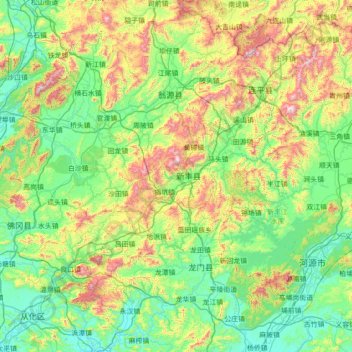
Name: Xinfeng topographic map, elevation, terrain.
Location: Xinfeng, Shaoguan City, Guangdong, PRC (23.41772 113.51302 24.69772 114.79302)
Average elevation: 310 m
Minimum elevation: 9 m
Maximum elevation: 1,324 m
Other topographic maps
Click on a map to view its topography, its elevation and its terrain.
Baiyun District
PRC > Guangdong > Guangzhou City
Baiyun District, Guangzhou City, Guangdong, PRC
Average elevation: 40 m
Jinkeng Reservoir
PRC > Guangdong > Guangzhou City > Jinkeng Village
Jinkeng Reservoir, Shuiku Road, Jinkeng Village, Huangpu District, Guangzhou City, Guangdong, PRC
Average elevation: 101 m