
Yerevan topographic map
Interactive map
Click on the map to display elevation.
About this map
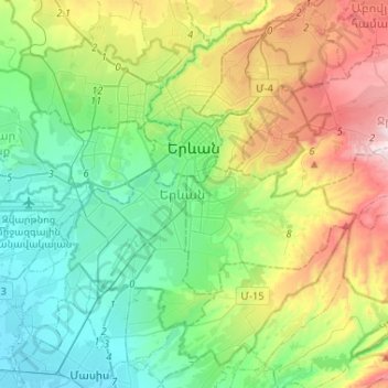
Name: Yerevan topographic map, elevation, terrain.
Location: Yerevan, Armenia (40.06585 44.36211 40.24177 44.62177)
Average elevation: 1,094 m
Minimum elevation: 826 m
Maximum elevation: 1,701 m
Other topographic maps
Click on a map to view its topography, its elevation and its terrain.
Amasia
Amasia, Amasia region, Shirak Province, Armenia
Average elevation: 1,946 m
Zovuni
Zovuni, Yeghvard region, Kotayk Province, Armenia
Average elevation: 1,194 m
Զվարթնոց օդանավակայան
Armenia > Armavir Province > Զվարթնոց օդանավակայան
Զվարթնոց օդանավակայան, Armavir Province, Armenia
Average elevation: 862 m
Gyumri
Armenia > Shirak Province > Gyumri
Gyumri, Border Gyumri, Shirak Province, 3104, Armenia
Average elevation: 1,711 m
Aragats
Armenia > Aragatsotn Province > Aragats
Aragats, Aragatsotn Province, Armenia
Average elevation: 1,962 m